|
|
Post by panzer0170 on Jul 23, 2014 18:31:26 GMT -5
Gentleman. I'm sure I'll pander you with questions shortly  |
|
|
|
Post by panzer0170 on Jul 23, 2014 19:07:27 GMT -5
So, lots of questions, some observations, I'm sure you have your reasons.
Fire and Signal:
Why a BLUE Chemlight specifically? Is it attached to string so you can 'buzzsaw' it?
Navigation:
I.... don't understand the logic behind having a GPS in an E&E kit. Even the small ones are big, and a good compass would be better suited with a quality map, if you're going to use the space. If you know your area remotely well, a map and compass is more than enough, and; no batteries!
Water/Food:
Are the Ziplock bags for water? How about a water filter. Sawyer do a tiny one that you can drink direct from a stream, and any old bottle (with a standard thread) will do as a container.
Medical:
Space Blanket - I assume this doubles as shelter, as there's no mention of it anywhere else and it's a key part of survival?
What is the purpose of the baby wipes? For single/few use items, they're bulky. If it's for sterilising you can use iodine for a variety of things, medically for sterilising wounds, and in water for treating it.
Tablets: For their weight? May as well!
|
|
|
|
Post by USMC0331 on Jul 23, 2014 19:27:28 GMT -5
So, lots of questions, some observations, I'm sure you have your reasons. Fire and Signal: Why a BLUE Chemlight specifically? Is it attached to string so you can 'buzzsaw' it? Better to see blood by.
Navigation: I.... don't understand the logic behind having a GPS in an E&E kit. Even the small ones are big, and a good compass would be better suited with a quality map, if you're going to use the space. If you know your area remotely well, a map and compass is more than enough, and; no batteries! Good compass (GI Lenstatic) and 7.5 maps, chart compass, UTM tool, etc. take up much more room and are in my BOB but for the E&E the primary is the button compass and altas page. The GPS is extra gravy and has almost all of Oregon on it which you won't get in maps in that size a package. Yeah, it and my primary sighting tool for my rifle take batteries. Keep them updated and have spares along with a backup.  Water/Food: Are the Ziplock bags for water? How about a water filter. Sawyer do a tiny one that you can drink direct from a stream, and any old bottle (with a standard thread) will do as a container. Ziplock is for extra water, the belt has a 32oz metal bottle in the dump pouch usually as the primary water source. The metal can will do in a pinch to boil water and put into gallon ziplock. Just having a straw and depending on drinking from a stream does not work unless you are following the stream, which I've found doesn't usually work because they lead you down into places you don't want to come out of. Around here, I would not be too worried about drinking from a "clean" stream without filtration but having a way (can) that doubles for water proofing seems like a good idea to me.Medical: Space Blanket - I assume this doubles as shelter, as there's no mention of it anywhere else and it's a key part of survival? Fire reflector, layer between natural cover. Quick way to retain/gather heat when fire is not an option. Small, light, what's not to like?What is the purpose of the baby wipes? For single/few use items, they're bulky. If it's for sterilising you can use iodine for a variety of things, medically for sterilising wounds, and in water for treating it. For wiping my but mostly. I getting old so I tend to forget which hand is for which when doing it the Korean way. Tablets: For their weight? May as well! |
|
|
|
Post by panzer0170 on Jul 23, 2014 19:53:26 GMT -5
So, lots of questions, some observations, I'm sure you have your reasons. Fire and Signal: Why a BLUE Chemlight specifically? Is it attached to string so you can 'buzzsaw' it? Better to see blood by.
Navigation: I.... don't understand the logic behind having a GPS in an E&E kit. Even the small ones are big, and a good compass would be better suited with a quality map, if you're going to use the space. If you know your area remotely well, a map and compass is more than enough, and; no batteries! Good compass (GI Lenstatic) and 7.5 maps, chart compass, UTM tool, etc. take up much more room and are in my BOB but for the E&E the primary is the button compass and altas page. The GPS is extra gravy and has almost all of Oregon on it which you won't get in maps in that size a package. Yeah, it and my primary sighting tool for my rifle take batteries. Keep them updated and have spares along with a backup. Water/Food: Are the Ziplock bags for water? How about a water filter. Sawyer do a tiny one that you can drink direct from a stream, and any old bottle (with a standard thread) will do as a container. Ziplock is for extra water, the belt has a 32oz metal bottle in the dump pouch usually as the primary water source. The metal can will do in a pinch to boil water and put into gallon ziplock. Just having a straw and depending on drinking from a stream does not work unless you are following the stream, which I've found doesn't usually work because they lead you down into places you don't want to come out of. Around here, I would not be too worried about drinking from a "clean" stream without filtration but having a way (can) that doubles for water proofing seems like a good idea to me.Medical: Space Blanket - I assume this doubles as shelter, as there's no mention of it anywhere else and it's a key part of survival? Fire reflector, layer between natural cover. Quick way to retain/gather heat when fire is not an option. Small, light, what's not to like?What is the purpose of the baby wipes? For single/few use items, they're bulky. If it's for sterilising you can use iodine for a variety of things, medically for sterilising wounds, and in water for treating it. For wiping my but mostly. I getting old so I tend to forget which hand is for which when doing it the Korean way. Tablets: For their weight? May as well! Re: Chemlight - Surely that's a medical use, not a signal use? I get the reason, just confused for it's location in your breakdown. Makes sense as a med item. Re: Compass - This will give you as accurate a bearing as any lensatic/prismatic compass, it will not run out, and it is slimmer than any GPS. GPS can be jammed. Easily and cheaply. If you're going E&E cut your 1:24k map down to a realistic area. Stick your state map to the back THEN fold it. Cut all the extraneous info off and learn anything you NEED (legend etc) so you don't need the extra paper. Have your E&E map marked with important things, if you live there you have the time NOW to go scout out important things, good routes etc. 'Extra gravy' is not something for E&E. GPS is awesome, but it is not E&E gear. If you're wearing belt gear then sure, go for it. But I would not consider this E&E gear, I'd have this ready to use ALL the time, if it were belt gear. Else it would get ditched. Water: Your method works, and is nice and cheap. But for clarity, my option isn't just a straw filter. It takes (included) collapsible bags OR any generic bottle you can get hold of. Youtube link. Costs more, but is a 1 time purchase. Space blanket: Agree! Arsewipes: If I'm E&E, the last thing on my mind is polishing my ring! |
|
|
|
Post by USMC0331 on Jul 23, 2014 21:41:34 GMT -5
I guess we are back into the "Evo of gear II" thread at this point, in that many items are not strictly E&E but crossover items. It's not a traditional .mil E&E kit by far (for one, there is no intent to take it and leave the belt behind like a traditional E&E kit), just stuff I want to have on me at all times.
For my E&E kit, a full navigation setup is not included. I keep one with my rifle data book that is in my BOB or "battle pack" if I were to be going on some kind of scouting party. I have 7.5s in the kit of the 4 surrounding grids on my AO, but I do like your idea of a 1:24 with several Atlas pages of the areas just outside of the map. I think I will have to make one of these for my AO and two bugout locations. Thanks!
The GPS allows me to know that I have 90% of my state at 7.5 level no matter where or how I got there. You can not get that in any other size package. Even if it were jammed, I can still use the map feature on it. Or so I believe, will need to test this. I just need to know my last position.
The GPS & E&E pouch both have 3ft of 550 cord for dummies that could be used on the chemlite. It could be put into the "tools" category, but since it has the ability to signal I include them in the Signal section when I write out gear.
|
|
|
|
Post by Diz on Jul 24, 2014 12:31:16 GMT -5
This is an interesting discussion because I am seeing two equally valid POV's. For those that have never trained with the Brits I would listen to what Panzer has to say. They have different ways of doing things that might cast a new light on what you are doing. I know it did for me. They seemed to have tried and true methods of doing things, with very little (as compared to American forces), with a tribal knowledge passed down through centuries of warfare.
BTW, there are state atlases out there with either lat/long or UTM grid coordinates for cross-referencing with topos. I keep these in my truck for general navigational use. And yes it's a PITA to have so many map sheets, but I don't trust digital media. As always, YMMV.
GPS use centers on the question of whether your government will monitor it, and, if you have cause to believe they might do you harm with that info. So for emergency search and rescue type stuff, sure, why not. BUT, if things really go sideways, I wouldn't trust the damn thing farther than I could chuck it.
|
|
|
|
Post by panzer0170 on Jul 24, 2014 13:51:48 GMT -5
This is an interesting discussion because I am seeing two equally valid POV's. For those that have never trained with the Brits I would listen to what Panzer has to say. They have different ways of doing things that might cast a new light on what you are doing. I know it did for me. They seemed to have tried and true methods of doing things, with very little (as compared to American forces), with a tribal knowledge passed down through centuries of warfare. BTW, there are state atlases out there with either lat/long or UTM grid coordinates for cross-referencing with topos. I keep these in my truck for general navigational use. And yes it's a PITA to have so many map sheets, but I don't trust digital media. As always, YMMV. GPS use centers on the question of whether your government will monitor it, and, if you have cause to believe they might do you harm with that info. So for emergency search and rescue type stuff, sure, why not. BUT, if things really go sideways, I wouldn't trust the damn thing farther than I could chuck it. Thanks for the props - We do some stuff well, but we can definitely learn to do Logistics better (we are, ours is... crap). As far as GPS use goes: GPS receivers (clue is in the name) are totally passive. No one can track your GPS receiver, assuming that is it's sole purpose (Garmin 301 for example.) What they COULD track would be a GPS enable phone or tablet (But that's cell tower stuff. Ask me how I know.) It is true that there are ground stations which correct the error in the clocks (theory of general relativity, and the fact that time passes at a different rate in space comes into play) However they are, on purpose, not all located in one country (assuming you're talking purely NAVSTAR and the US system, and not Galileo over Europe or the Russians GLONASS.) There is one in the UK, and several others around the world. To take them ALL out would require something along the lines of a world war and targeted strikes, whilst leaving the other systems (galileo, glonass) functional and your GPS working... GPS JAMMING on the other hand, over smallish areas, is ridiculously easy, cheap and simple. Basically all you have to do is transmit on that same frequency, with more power. Boom. No GPS. The big PITA for GPS is heavy tree cover, canyons, or high rise urban areas. My personal issue with digital mapping and a lack of paper copies is that you can't update them. you can't scribble notes on. you can't edit them, which is.... bloody annoying. Unless you have a GIS package and know how to convert things from one format to another (And bugger messing about with that, WROL/SHTF) What I WOULD suggest as an excellent method of helping navigation, which is taught from a more mountain rescue/civilian aspect is 'back snaps' - taking photos of where you just came from, for if you have to backtrack. Now what you can do is take these NOW, get co-ords, write them on the back of hard copies, and number them. Link them to your maps, you can then show a person what they are expecting to see when they reach location X. It's a BRILLIANT confidence booster for people who are shaky with navigation, and has a whole host of other uses (intel/recce type stuff). I get sticky, when it comes to Maps/GPS/Navigation. Some people are guns folk, some are medical, some are comms. My 'thing', for my time, was maps. We made maps, taught navigation, micronav, how to use GPS, worked with GIS software and the works. I could BORE you, talking about datums, geoids and spheroids, about how a triangle can have more than 180 degrees in it (This is part of the maths that makes GPS work!) And a whole host of other crap. Honestly, I see the place for GPS, but is, in american terms 'snivel gear'. (It's the first thing on the list I'd pack, if I was going to pack ANY snivel gear. But it ISN'T necessary. Bloody handy if you're a RadOp though, especially if you have a GPS watch or a GPS that straps to your wrist. No reading a map, just look at your wrist and start talking!) |
|
|
|
Post by USMC0331 on Jul 24, 2014 14:55:39 GMT -5
Good point on the GPS signal being manipulated or shut off completely in a tyrannical .gov scenario.
For maps: a little know resource are "ranger maps" that are about $6 at their stations and are 1:24 I believe. The nice thing is they show currently closed forest roads.
|
|
|
|
Post by panzer0170 on Jul 26, 2014 3:37:59 GMT -5
Good point on the GPS signal being manipulated or shut off completely in a tyrannical .gov scenario. For maps: a little know resource are "ranger maps" that are about $6 at their stations and are 1:24 I believe. The nice thing is they show currently closed forest roads. Not even tyrannical gov scenario: commercial drivers buy 12/24v pre-made ones that will jam any sort of company low-jack, and I can see a place for them in criminal circles. (Here, it's illegal to jam radio signals, and breaks the wireless telegraphy act - which was set up mostly a sane excuse to lock up Russian spies forever, it actually has bigger sentences than murder etc available if you break it We used to use them on exercises to FORCE map/compass only nav. |
|
|
|
Post by USMC0331 on Jul 27, 2014 20:59:52 GMT -5
Jamming and Encryption use are illegal here also. I doubt the range of anything non-military would be of issue if using a GPS in the woods. Like everything else, have a backup plan. Orienteering is fun but takes practice.
I was teaching my wife some last year on hikes and you realize quickly that all those years of experience don't happen overnight with a new person. It's very easy to take for granted the little things about it, and I'm no expert. I consider myself at the most basic of level even after teaching it in the Boy Scouts and some .mil experience in Okinawa triple canopy along with mapping/trekking my own AO in the past few years. While playing "Geo-Shooting" with a buddy.
My Advice on it:
Once you go UTM, you will not go back!
Better know which you are using and have a way to switch between DATUMS!
Practice.
|
|
|
|
Post by panzer0170 on Jul 28, 2014 4:03:15 GMT -5
Jamming and Encryption use are illegal here also. I doubt the range of anything non-military would be of issue if using a GPS in the woods. Like everything else, have a backup plan. Orienteering is fun but takes practice. I was teaching my wife some last year on hikes and you realize quickly that all those years of experience don't happen overnight with a new person. It's very easy to take for granted the little things about it, and I'm no expert. I consider myself at the most basic of level even after teaching it in the Boy Scouts and some .mil experience in Okinawa triple canopy along with mapping/trekking my own AO in the past few years. While playing "Geo-Shooting" with a buddy. My Advice on it: Once you go UTM, you will not go back! Better know which you are using and have a way to switch between DATUMS! Practice. A little, handmade device that fits inside a cigarette box, powered by a 9V battery, will jam GPS not using The military signal for between 2-5 miles, line of sight. More tree cover = limited range for jamming, but the trees will help do the job (canopy cover dependant) If I did have some & they were legal, or it's WROL/SHTF and it doesn't matter, using them to cover complex approaches (where navigation is complex) and/or key stretches of road might impart an advantage (against SOME devices) esp if they centre their maps on where they think they are. Even people who have maps with them now have an extra task (compasses and 'proper' nav) to distract them (assuming they need it because they're non-local, and you know the area intimately. It is, for the most part, a rather minor consideration, mind you. As far as UTM goes: It's alright. I prefer MGRS, and, depending on the size of the AO, national grids are excellent. British National Grid = better than UTM because UTM operates over 2 zones in the UK, and compass bearings don't translate well, in the overlap. It also requires, for Comms purposes, some rules/agreed on usage of when you will change from UTM zone 12A to zone 34B etc. If you are entirely within 1 UTM zone? Excellent news, UTM is tidy. (Example: Both Washington & Oregon are split in half by zones 10/11. If you live central, you need to remember to swap between zones when using the map (GPS does it for you, of course!)) Attachments:
|
|
winter
Junior Member

Posts: 479 
|
Post by winter on Sept 6, 2014 0:08:08 GMT -5
 Why didn't any of you tell me that wrestling a 2 quart off a belt rig was hard and putting it back in was impossible? Blue Falcons |
|
|
|
Post by USMC0331 on Sept 6, 2014 10:25:03 GMT -5
Because something's ya gotta experience for yourself. I thought it odd but if it worked for you, I figure "rock on" I prefer something I can boil water in on my belt kit and use a stainless WB because it's easy to drink from and has multi purpose. Primary water is out of camelback in pack, you might replace one of yours with a standard canteen and cup or a Condor WB carrier and stainless WB and see if that works. The standard 782 gear canteen pouch was never a favorite of mine either and I'd use a Tactical Tailer over it. Sent from my iPhone using Tapatalk |
|
winter
Junior Member
Posts: 479
|
Post by winter on Sept 9, 2014 15:08:34 GMT -5
I just switched back to a canteen and cup. I live in a rainforest so having 2 qts on my rig is not really necessary. It fit perfectly though...  |
|
|
|
Post by norinco on Sept 16, 2014 14:28:51 GMT -5
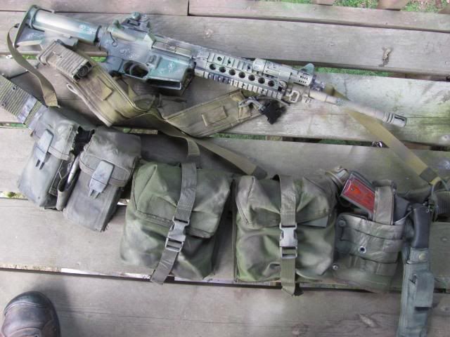
 From Left to Right Surplus MOLLE belt and low profile suspenders Maxpedition Dump Pouch HSGI Universal Mag Pouch with 4 AK mags IFAK with Izzy bandage, tourniquet and gauze, etc. Pouch with spare pistol mag and multitool SAW Pouch with Sawyer Mini water filter, chemlight, binoculars, Mechanix gloves, 3 Clif bars, mylar bivy bag (green) Canteen pouch with Nalgene cantene, canteen cup and stand, trioxane fuel x 1, lighter and camo face paint Condor holster with Glock and TLR-1 flashlight (Blue gun shown as reference) Tactical Tailor Universal Mag pouch with 2 AK mags Pistol mag pouch  Velocity Systems Lightweight Plate Carrier Mayflower R&C 7.62 Placard Pistol mag and multitool in left pouch Izzy Bandage in center pouch Tourniquet in right pouch. My goals with this setup were to be able to mix and match depending on my needs. I can wear the battlebelt setup by itself when patrolling or add the plate carrier if necessary for more volatile situations. I can wear the plate carrier by itself with an IWB holster both concealed under a shirt. Or just the plate carrier with the placard in a situation involving vehicles with extra ammo in a patrol pack. Not shown: Large Alice pack and day-sized packs Always open to constructive criticism. |
|


